 |

|
|
|
District |
|
Pribaikalsky |
|
Buryatia |
|
 |
|
|
Site of the Pribaikalsky central regional library |
 |
|
 |
Pribaikalskiy district
Pribaikalskiy district was founded on the 12th of December, 1940. Its territory
is 15472 square km, and the population of it numbers 28,700. The center of the
district is Turuntayevo settlement, situated 57 km far from Ulan-Ude.
Continue >>> |
 |
 |
 |

|
 BAIKAL: FROM THE HISTORY OF MASTERING BAIKAL: FROM THE HISTORY OF MASTERING
The first investigator, who left his followers "The scheme of the Baikal and
rivers flowing into it" and information about the lake's fishes and fur animals
inhabiting the coast's taiga, was a Cossack land discoverer Kurbat Ivanov. In
1643 with a gang of Cossacks and tradesmen he left Verkholensky fortress and
reached the western coasts of the Baikal and visited the island of Olkhon.
Continue >>>
|
|
Buryatia |

|
|
History
monuments
|

|
|
 Buryatia…
This short tuneful word is the name of the region situated in the
Eastern Siberia. In the North and in the West its territory is framed by
world-famous sacred Lake Baikal and in the South by the endless steppe of
Mongolia. Buryatia…
This short tuneful word is the name of the region situated in the
Eastern Siberia. In the North and in the West its territory is framed by
world-famous sacred Lake Baikal and in the South by the endless steppe of
Mongolia.
Continue >>>
|

|
|
|
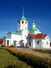
 The
orthodox churches have begun to build in Transbaikalia Russian, when 17
centuries have put up here at middle. The stone church in a village Turuntaevo
is constructed in 1791-1818. Almost at the same time (1813-1834) the church in a
village Baturino is constructed. Since 90 years XX of century of church are
restored. It is surprising, but many yesterday's opponents of religion became
the christians. The
orthodox churches have begun to build in Transbaikalia Russian, when 17
centuries have put up here at middle. The stone church in a village Turuntaevo
is constructed in 1791-1818. Almost at the same time (1813-1834) the church in a
village Baturino is constructed. Since 90 years XX of century of church are
restored. It is surprising, but many yesterday's opponents of religion became
the christians.
Continue >>>
|

|
|

|
|
"Sacred sea"
|
"Sacred sea",
"sacred lake", "sacred water" - these names have been given to Lake Baikal since
time immemorial by the indigenous population, by the Russians who came to these
shores in the 17th century, and by foreign travellers in their admiration for
its majestic and unearthly beauty.
Continue >>>
|
|

|
|
Climate
The
republic of Buryatia is situated in the South of Siberia. From the West to the
East it covers the area between the 98°40’ and 116°55’ of the eastern longitude.
Its most northern point is at 57°15’ of the northern latitude, and the most
southern point is at the river Chikoi at 49°55 northern latitude. The total area
is 351.3 thousand square kilometres.
The
climate is continental, dry, with a lot of sunny days.
Continue >>>
|

|
|
|
|
|
Zakaznik Pribaikalsky - game reserve

ª
The
Pribaikalsky Zakasnik covers an area of about 70,100 ha and is located in the
Pribaikalsky Administrative district of the Buryatia Republic, within the
boundaries of Kikinsky leskhoz and Verhne-Itantsinsky and Gremyachinsky
lesnitchestvos (ranges).
The zakasnik is
situated on the eastern coast of lake Baikal, some 100 km to the north west of
Ulan Ude. It can be reached via the main road going to the north (R 438), which
passes the capital of the Rayon Turuntaevo after 50 km, and which reaches the
lake shore at Gremyachinsk, the village where Kikinsky leskhoz headquarters is
located.
Continue >>>
|
|
|
 |
ª
|
